Tuesday, July 27, 2010

Hike 14: Paradise to Camp Muir 2

After our last hike to Camp Muir didn't go so well, we knew that we had to try going up one more time to see how I would handle the altitude. I made sure to talk to lots of people about my headache issues and got a lot of good advice. I called the guides at Alpine Ascents to ask them what to do about my headache, and they thought that I had enough water, but that I was just extra sensitive to altitude. I asked them exactly what they did when they hiked up, and he said that they stop every hour for 15 minutes. So on Saturday, I brought a stop watch and timed it so that we could do exactly that. I also took their advice and bought some Nuun electrolyte tablets to put into water instead of using Gatorade, which has a lot of sugar in it. Nuun has several flavors and it is very tasty. It worked out great for me. Also the week before we practiced going to bed early and getting up 30 minutes earlier each day of the week, so when 4:30 am rolled around on Saturday, we were ready for it. And the last, and probably the best thing we did, was baked a Papa Murphy's gourmet veggie pizza and put four slices in our bags to eat at each stop. They say that it doesn't matter what you eat on the mountain, just as long as it has enough calories and as long as it is appetizing. When at elevation, your body doesn't really feel hungry, so it is important to eat no matter what. I don't think that I ate enough last time, so we made sure that we had good food for fuel.

On Saturday morning we picked up my co-worker Garrett on the way to Rainier. He is also a Climb to Fight Breast Cancer participant, but his expedition is on August 21, two weeks after ours. If we made it to Camp Muir, it would be his first time to 10,188 ft.

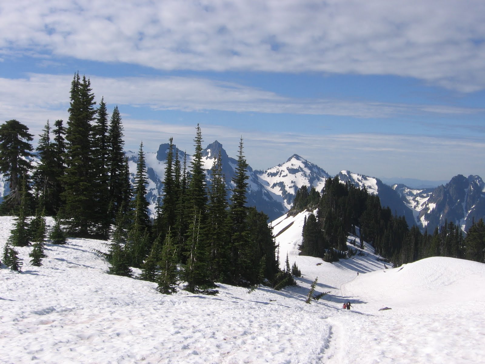
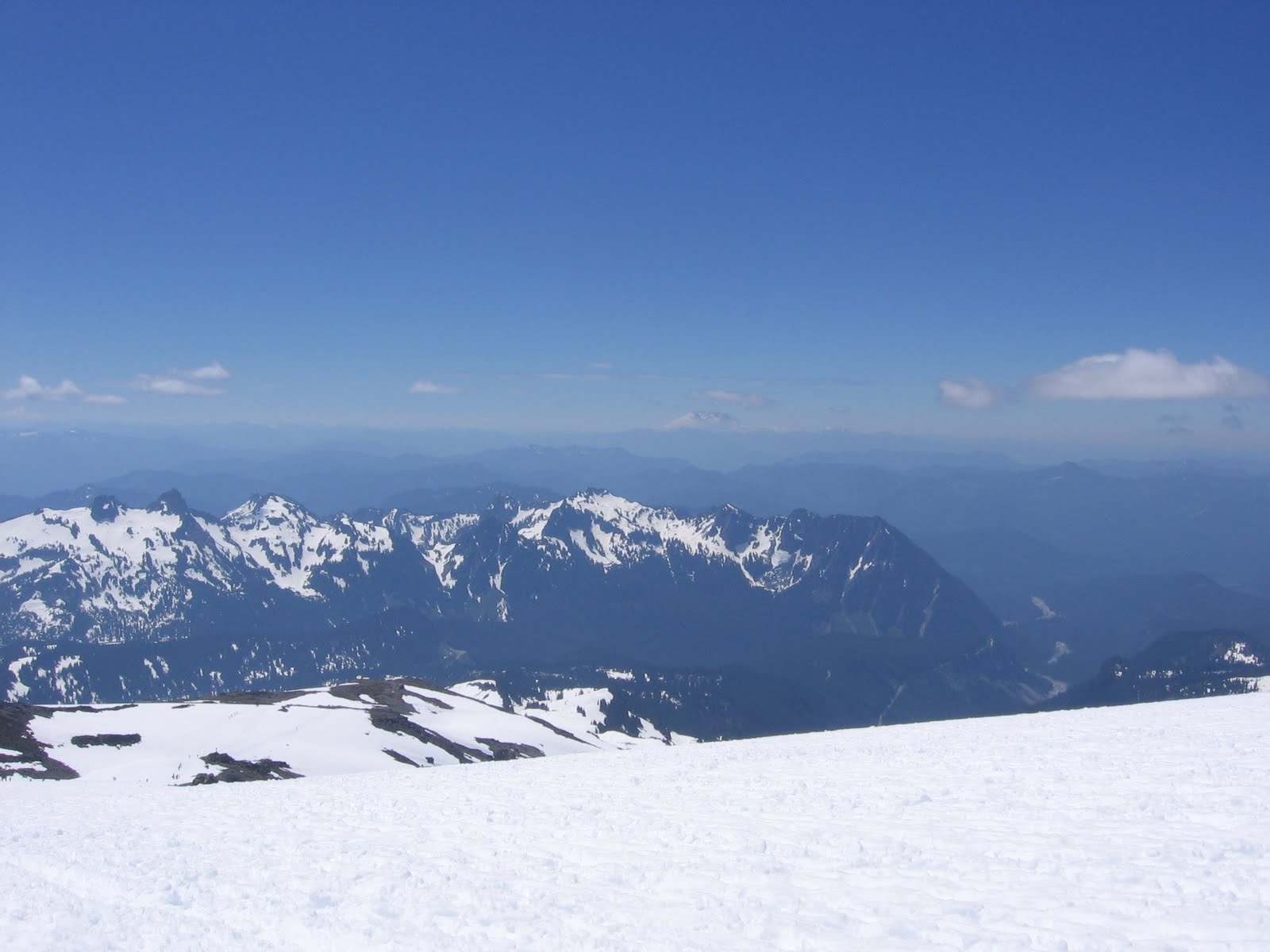
The weather was stellar at about 70 degrees and sunny. It felt cooler than July 10th because of a nice breeze coming off of the snow. The trail up to Muir looked different than last time because the snow is continuing to melt, so the park rangers constantly are changing the route. In June we couldn't see the 12 foot trees near Paradise, which means we were probably walking over the top of them. On Saturday, there wasn't any snow at all for the first 1/2 mile or so. This makes it tough walking in our plastic boots, but overall the route is getting easier and more direct.

Not a cloud in the sky.

On our way up we kept leapfrogging with another group that consisted of an older woman and a few others. She looked very strong and had obviously been on a few mountains in her life. We estimated that she was in her early 70's, but we weren't for sure. Garrett was brave enough to ask her how old she really was when we saw her at Muir. She seemed only partially surprised at the question and then answered, "I'm 85 years old." We were shocked! Not only did she make it up to Muir, but she made it as fast as we did, and we're almost 60 years younger than she is! Wow!

After our first hour, we stopped in the shade of some rocks and took a break. That slice of pizza sure tasted good. Then we went another hour and stopped for another 15 minutes. After the third hour, we sat on a few rocks and enjoyed the view for around 30 minutes, for a total break time of one hour. After the third stop, I started to get a headache like last time around. Then I remembered what a colleague of mine told me about pressure breathing (#4 in this good article on coping with altitude). It is a technique that forces the CO2 out of the lungs so that oxygen exchange is better and headaches don't occur. I continued to pressure breathe all the way to Muir and felt a hundred times better than before. We arrived around 2 pm, after 5 hours of hiking, which is about average.

A couple of huts at Muir.


Enjoying the view...Mt. Adams is just to the right of my head. It rises to about 12,300 feet and looks a lot like Rainier.


Lots of people at the top, but not as many as July 10th. We couldn't figure out why there weren't as many people hiking this time, but it made for a nicer trip.


A group making it to the top.


After about an hour, we ventured down, this time by glissading...a fancy term for sledding down snow chutes. We brought heavy duty plastic bags and proceeded down the mountain. We probably went on five different chutes that varied in length, which cut down our descent time to two hours instead of three.


After a successful day, we drove home and saw a full moon, which looked like it was right next to Rainier. Those staying overnight on the mountain probably had an amazing view. We can't wait until our overnight trip to the summit, which is less than two weeks away! Can't wait!


Tuesday, July 20, 2010

Hike 13: Rainbow Lake in Whistler

For my birthday we visited Whistler, BC, a hub of incredible outdoor recreational pursuits like ziplining, biking, kayaking, fishing, rafting and of course, hiking. Even though it was more of a birthday vacation, we brought our packs with us and planned for a long hike on Saturday. We stopped in the Whistler Visitor Centre and asked where a good long hike is, and the guide told us about Rainbow Lake. It is just a short drive from Whistler Village and measures 16km long and an 850 m elevation gain. For those of you who don't want to do the conversion in your head...that's 9.94 miles roundtrip with a 2,788 foot elevation gain. Whistler sits at about 2,200 feet, so we got to about 5,000 feet at the top.

The trail was absolutely gorgeous because it was so diverse. We hiked on gravel, rocks, streams, dirt, bridges, boardwalks and snow. We even had the rare opportunity to see 3 moose while hiking up. We couldn't get the camera out before they ran away, but we really did see them! It was our first time seeing moose in the wild.


This suspension bridge was very wobbly.


Here's Rainbow Lake, slowly melting from left to right.


A good reflection shot.


The green squiggly lines on the right side of the mountain are the famous Blackcomb ski trails, where tons of people visit in the winter.

This Saturday we are going to Muir again, but this time preparing more by getting up early during the week and hydrating a lot on Thursday and Friday. We also got some good advice from other climbers about hydration and elevation headaches. We'll see what happens...


Tuesday, July 13, 2010

Hike 12: Paradise to Camp Muir

Our latest adventure was on Saturday, July 10. We had plans for a while to try to get to Camp Muir again, so we were thrilled that the weather was in our favor and the sun was out. It was relatively warm in Paradise when we arrived at 8 a.m. After getting all our gear on, we set out on the trail. It was a clear day, which was in sharp contrast to our attempt in June. We were actually able to see the summit as well as several mountains in the distance.


The trail starts at 5,400 feet.

The summit had a subtle cloud over the top for most of the day.

Click on the picture above to see that just to the left of me, a deer came out of the bushes and ran across the path. It was probably only 10 feet away...not sure who was more skiddish, me or the deer.

Great view of the trail behind us.

Since we were surrounded by clouds on our last hike, we couldn't really tell where we were in relation to trees or Paradise or rock piles. It was nice to see everything this time.

In the distance is Mt. Adams.

There's Mt. St. Helens, which erupted 30 years ago in May.

Here's Brian looking ready to get to the top.

If you click on the photo above, it will get larger and you will be able to see all three peaks, Mt. Adams in southern Washington on the left, Mt. Hood in northern Oregon in the middle, and Mt. St. Helens in southern Washington. It was amazing.

Our second wildlife sighting was this marmot. He was running across the trail too trying to get away from the hikers. We later saw four more marmots and two were fighting for the best place on a particular rock.

We're probably at 7,500 feet here.

It was a sunny day, so we applied sunscreen five times on the way up and down. It was worth it because we didn't get burned at all. However, the sunscreen did get in our eyes on the way down...another joy of hiking.


If you click on the photo above, you'll see the rock in the middle, which is called Anvil Rock. That is where Camp Muir is. From the trail, it doesn't look very far, but the mountain is deceiving.


Here's a shot of the many people on the trail. We probably saw at least 300 people on the way up.

This hill was the last steep one until Muir.

A headache started to kick in for me here. I'm not sure if it was dehydration or altitude, but it wasn't very pleasant. On our next hike up to Muir on the 23rd, we're going to be more diligent about drinking 1/2 liter of water and electrolyte drinks every hour, stopping every hour to eat (probably pizza!), being hydrated before the hike and getting lots of sleep the week before.

Getting closer...

There's Mt. Adams in the distance. It sort of looks like Rainier, but it is a bit shorter at 12,281 feet.


Here's your geography lesson.


We made it to Camp Muir! All of the tents are lined up for the night. Most of these people will be trying to summit in the next couple of days. It seemed like a small village with people chatting, hanging out, and waiting for the outhouses...yes, there was a line for the three outhouses.

The hut to the right belongs to the ranger from the national park.


There's the three outhouses with a few people patiently waiting...


After reaching Muir, we headed back down. After six hours of hiking up, it was a bit difficult to go down. But we made it in another three hours, which means we were on the mountain for 9 hours total. Needless to say, we were slightly exhausted after waking up at 4:30 am. We finally made it home at 10:30 pm and promptly went to sleep.